
The weather was perfect, so I had to take a bike ride. It started quite normally, following a fun route of twisty paved roads just like I’d planned. Somewhere along the way I missed a turn but found myself on a gravel road through a beautiful scenic area, so I decided to follow it for a while. I passed Dougan Falls, then Naked Falls, riding alongside a small river.

I was about ready to turn around and head back the way I came, but I had the idea to try having my Garmin plot me a route home using the “Garmin Adventurous Routing” option. This feature seeks out the fun roads and tries to avoid highways as much as possible. The route continued forward, down several miles of unpaved roads, and got me home on city streets, which sounded great. Since the Garmin knew the way, I pressed on ahead. This is when the real adventure began.

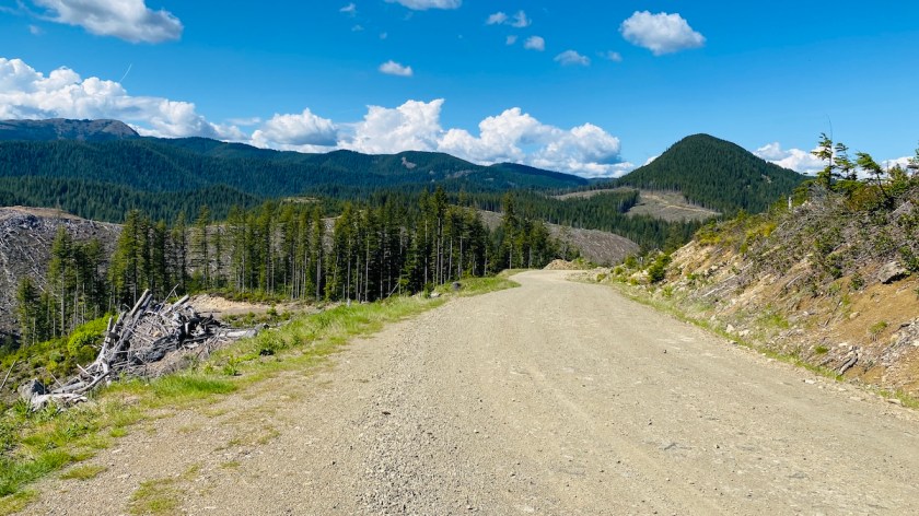
I left the parks and any signs of civilization. Eventually, I realized I was in the middle of a huge logging area. There were no gates, and absolutely no signs telling me where I was or that this was private property, but the evidence of logging was quite clear. I know what logging roads look like from all those times I worked the New England Forest Rally, which runs on logging roads. By this point, I was far enough in that I decided I was better off sticking to my route than turning around and going back down literally 10 or 15 miles of logging roads.
Some of these roads were in great shape. Others were covered in loose gravel, causing the bike to shift around underneath me. A couple of years ago this would’ve frightened me, but now I knew that as long as I maintained enough speed, the bike would stay upright on its own without me micromanaging every control input. Aside from the logging, there were quite a few trees down across some of these roads, to the point where nothing wider than a motorcycle would be able to get by. I pressed on.

I might have been lost in the woods, but that didn’t mean I couldn’t stop and enjoy the scenery from time to time. That scenery was well worth enjoying, views that few people besides loggers ever get to see. From some hilltops, I could see miles and miles of forest around me, or areas that had been deforested by logging operations. This had to be the most scenic, beautiful off-road ride I’ve ever taken. It’s what adventure motorcycling is all about.
There were a few sketchy parts. The loose gravel continued, and there were often steep drops on the side of the road with no guardrails. Don’t screw up. At one point I rode straight through an actual logging operation, only dormant at the time because it was after working hours. I got a little scared when I saw the crane that 1. I was going to get in trouble, and 2. I wouldn’t be able to get out that way, but neither of these turned out to be the case. Regardless, my only goal at this point was to get back to a public road.

At one point the temperature cooled off, and there was snow on the side of the road. Just as I wished for no snow on the road — or at least enough clear road for me to get by — the road became partially snow-covered in the shade. Fortunately, my wish was fulfilled, and I was able to get by. Not long after, the snow completely covered the road, except for two clear stripes that truck tires had left behind. I slowly pressed on through one of them. It was muddy since these were now channels for all the water from melting snow, but with a good back tire and brand new front tire, I had enough traction to get through. Normally I would not have taken a risk like this, but the alternative was going back literally 20 miles of logging roads to where I’d come in, and I wasn’t sure I could find my way.
Another growing concern was gas. I hadn’t filled up because I was intending to go for a quick road ride but then found myself in over my head. Fortunately, the Kawasaki KLR650 has a 6.1-gallon fuel tank. Although off-road riding is not as efficient as street riding (I learned that the hard way in Yuma, Arizona), I didn’t need to even think about gas until I hit the reserve tank. Then it would become a concern, but I knew I still had a good chunk of fuel left after that.

After more than 20 miles on various “Unpaved Roads,” according to the Garmin, I went down a narrow, loose gravel section looking for a left turn onto a road with an actual name. This was good news, as it was likely my way out. It was not to be — the road literally didn’t exist. I could barely see where it once might have, but huge boulders and tree growth blocked where it might have once gone.
I went back into the Garmin and used the “Detour” function to find another route. I also turned off “Garmin Adventurous Routing,” opting instead for the fastest route. I’d had enough adventure at this point. Then I went back the way I came to another named road. This one did exist, but looked like only heavy logging equipment could get down it. I shut off the bike and walked down a little way. I might have been able to get down it. If it also turned out to be wrong, though, there was no way I could get back up the steep hill. I chose not to take that risk.

I used Garmin’s “Detour” function again. Since I had a cell signal, I also pulled up Google Maps on my phone to see what route it suggested. Both of them seemed to agree on one, which gave me a glimmer of hope. At this point, I was considering plans to find the local non-emergency police phone number to call for help getting out of there. I’ve actually called the police for help when I got lost in the woods once before. I was in much better shape this time, though, since I had plenty of daylight and was very much mobile, not stuck between two difficult trails in the dark.
Along this route, the logging road was in good shape. After a while, I started to see numbers painted on trees, first 6, then 5 1/2. They were counting down, and the distance between them corresponded to half a mile. Once again, I’ve seen this before on logging roads in Maine. They were counting down the miles to the exit. I was on the right track! The only thing that could stop me was if this road, too, ceased to exist at some point. But it didn’t.
I rode right up to the backside of a gate blocking the road. I looked to see if I could open it, but there were literally six different padlocks keeping it shut. They clearly didn’t want people like me getting in. Though if that’s the case, why weren’t there even any signs telling me to keep out on the road where I’d come in? I certainly would’ve obeyed them if there were any. Anyhow, fortunately for me, there was just enough space for me to walk my bike around the gate next to yet another steep dropoff. I chose to walk it rather than risk riding — one small mistake and I’d go over the edge. But walking it through slowly was no problem. If this hadn’t been an option, I would’ve carefully laid the bike down on its side and taken it under the gate.
I was back on a gravel public road, complete with a speed limit sign. This soon led me back to the pavement, where I stopped, relaxed, and swung my DoubleTake mirrors back into place for road use. (When the logging roads got sketchy, I swung them in so that they wouldn’t get broken if I dropped the bike. It’s not like I needed to see any traffic behind me.)

Just a mile or two later, this paved road dropped me out onto Highway 14, just east of Cape Horn. I recognized where I was almost immediately from my previous ride out here. It’s strange, but even though this is my first time in Washington, I actually knew where I was!
It was an uneventful ride back. I stopped in Washougal to get gas. The price was too high, even by today’s standards, but I had no idea when I’d hit reserve, and I’d already had too many surprises for one day. Then I had an easy ride back to the house. I threw a couple of beers in the freezer for a quick chill, one for me and one to share with Darryl. I’d certainly earned it.
Obligatory disclaimer: In no way do I suggest or condone riding on private property without permission. I did, but it was completely by accident. If there was a gate or even one sign on the road I’d come in on stating it was private property, I would’ve stayed out. There wasn’t, and I didn’t figure it out until it was too late. From that point on, my only goal was to get back to public roads.
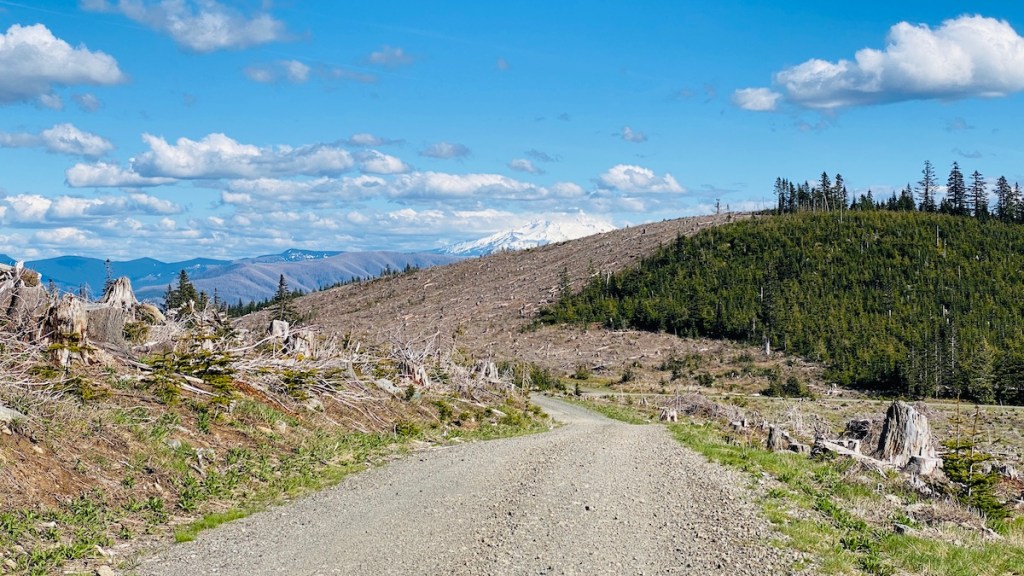
It was one heck of an adventure, though. This was more of an adventure than I prefer, but it sure makes for an interesting story. And those views! I literally stopped in the middle of the road at one point when I came around a curve and Mount Hood dominated the sky ahead of me. I only stopped to capture a fraction of the beautiful views I saw, since I was focused on getting out of the logging area. A few times, though, I just had to, and those are the pictures you see here.
I’m also thankful for everything I’ve learned about off-road riding. Even a year ago, I doubt I would’ve escaped without dropping the bike on loose gravel somewhere. As I like to say, “No whammies!’ Most of all, I appreciate my adventure tractor, my Kawasaki KLR650, for being so bulletproof reliable that, with everything else I was worried about, I never had to worry about whether it was up for the task or would get me out of there. And it did.

Nice
LikeLiked by 1 person